


Efficient infrastructure management has never mattered more — in developed and developing regions alike.
From oil and gas to insurance, the cost of efficient infrastructure management is extremely high, but the cost of inefficient management is far higher. With XL data, we're helping to take monitoring and management efforts to new heights.
"AGING INFRASTRUCTURE IS A GLOBAL PROBLEM, IN DEVELOPED AND DEVELOPED REGIONS ALIKE, IMPACTING ALL ASPECTS OF MODERN HUMAN LIFE: CORPORATE, ENVIRONMENTAL, AND SOCIAL."
"INTERFEROMETRIC SYNTHETIC APERTURE RADAR DATA HAVE TRANSFORMED EARTH SCIENCE." — SCIENCE.ORG
Mining
Land movement during mining operations can be disastrous and costly. Regular monitoring and geo-hazard detection with XL data can cover mines, tilling pools and other related infrastructure.

Construction
Because of SAR's ability to image below smoke and at night — with simultaneous bands — XL data can enable heightened detection, tracking, and management of forest fires.


Infrastructure
Infrastructure is a global challenge that impacts all aspects of human life. Mismanagement can lead to casualties and losses in the billions. Meanwhile, expanding urban populations, budget cuts, and increased inspection costs increase pose increasingly complex challenges.


Risk Assessment
SAR-XL is designed to detect, track, and predict natural disaster impact based on vegetation, land feature changes, and land subsidence. More precise and continual predictions can be made with reliable and consistent data, enabling accurate forecast models.

Insurance
Population growth in urban areas combined with shifting agricultural practices and climate shifts will continue to strain insurance needs and resources. XL data can provide accurate and efficient data to support decisions and claim investigations. reducing costs.


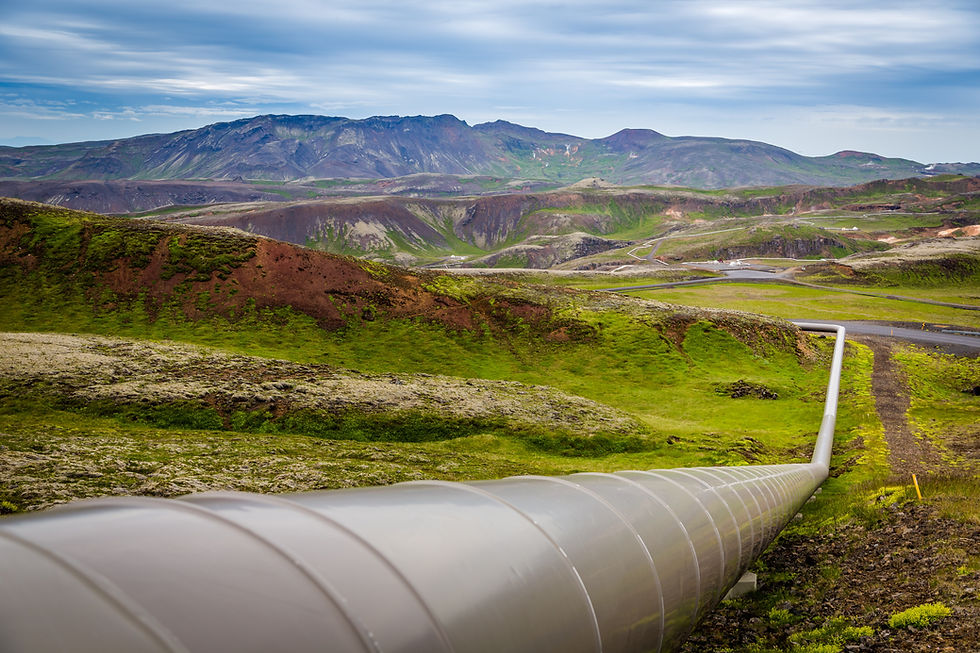
Oil & Gas
From leaking pipelines and oil spills, to landslides and volatile markets — XL data can deliver superior tracking, insight, and prediction thanks to in-space processing and dual-band capture. The result? Greater operational efficiency, lowered costs, and improved compliance.

Challenges this large require XL solutions.
From construction to natural disaster detection and response, the cost of efficient infrastructure management remains extremely high across sectors.
XL data marks a new era of geospatial intelligence for global applications, with information captured and processed in space, aided by AI and machine-learning integrations. These novel capabilities can result in vastly improved monitoring, management, and response.
SAR-XL Applications
↓

IN FOCUS
Civic Infrastructure, Insurance, and Resource Management
Aging infrastructure is a growing problem across the globe, impacting nearly every facet of human life: communities, individual health, businesses, and the environment. Mismanagement can lead to human casualties and cost billions of dollars. Meanwhile, existing challenges are made all the more demanding by the rapid expansion of urban populations, budget cuts, and the increasing cost of management.
XL Data Can Help
↓
Agricultural Monitoring
Key Global Challenges
-
Accessibility — Developing regions and small-scale farmers lack access to high-quality, affordable data and tools
-
Adoption — In developed regions, there has yet to be rapid adoption of available data and tools
Crop Analysis — classification, yield estimates, growth projections
Soil Moisture — below thick foliage and crops
Land Analysis — field size, composition, etc.
Integrations — hydrological and crop-growth models
Monitoring — over the growing season, and year over year
Detection — agricultural activities, harvest sizes, weather damage
The SAR-XL Difference
Improved Land Analysis
SAR-XL allows for greater accuracy, wide-area coverage, and high-resolution data delivery. This data, which is processed onboard the satellite, can be analyzed in an instant. Over time, this allows for more precise predictive farming.
Size Meets Precision
Simultaneous bands make for improved data utility. L-band data provides wide-area coverage, while X-band data allows high-res accuracy, for improved analysis.
Massive Coverage
Huge swaths of land can be coverd, with strips as wide as 400km. When combined with high sensitivity to soil and crop characteristics, this can significantly increase the utility.
In-space Processing
High-speed processing, AI, and ML allow for reduced latency with efficient, accurate analysis Pre-processing allows for better utility Augments optical and SAR datasets.
Key Areas of SAR Application

of the globe's freshwater is used for agriculture
70%
people are food insecure, while rural women and children are along the worst effected
2.3B
of rural livelihoods are tied to agriculture
~86%
"NOW, AGRICULTURE IS IN THE EARLY DAYS OF YET ANOTHER REVOLUTION, AT THE HEART OF WHICH LIE DATA AND CONNECTIVITY. ARTIFICIAL INTELLIGENCE, ANALYTICS, CONNECTED SENSORS, AND OTHER EMERGING TECHNOLOGIES COULD FURTHER INCREASE YIELS, IMPROVE THE EFFICIENCY OF WATER AND OTHER INPUTS, AND BUILD SUSTAINABILTIY AND RESILIANCE ACROSS CROP CULTIVATION AND ANIMAL HUSBANDRY."

"[SAR] HAS EMERGED AS A PROMISING TOOL FOR RAPID AND ACCURATE MONITORING OF WETLAND EXTENT AND TYPE. BY ACQUIRING INFORMATION ON THE ROUGHNESS AND MOISTURE CONTENT OF THE SURFACE, SAR OFFERS UNIQUE POTENTIAL FOR WETLAND MONITORING."
Water Management
Key Issues
Efficient water management — aided by technological innovations like SAR-XL — is critical to reducing water wastage and flooding. With SAR data, we can determine everything from water body dimensions to water-flow rates, while measuring and predicting floods.
Fresh water will continue to be an increasingly precious resource as human populations grow and flock to arid urban centers. As a result, freshwater reserves will continue to be depleted, large-scale agriculture will demand more irrigation, and wetlands will remain threatened.
Key Applications for SAR-XL
Agricultural irrigation planning
Mapping surface water
Flood monitoring and prediction
Tracking transformation of wetlands and aquifers
Snowpack and permafrost changes
Coastline water level measurement
SAR-XL Management Highlights
L-band SAR
Penetrates soil to determine water content for uses like irrigation, while also determining crop health and near real-time flood monitoring.
Digital Elevation Models
Can be determined and applied to characterize watersheds and hydrological changes.
Faster Mapping
Thanks to SAR’s sensitivity to water content, which helps to map surface water and measure soil moisture content.
SAR Accuracy
An accuracy of over 95% improves monitoring over time.
Improved automated classification, tracking, and learning over time — including onboard processing, AI, and machine learning — which will result in more timely and useful data. While singleband SAR poses issues when studying water systems, combined bands can add much needed accuity.
What's Next
Insurance Management
Critical Areas
Natural disasters
Extreme rainfall
Property assessment
Risk assessment
Flooding
Hurricanes
The Difference SAR-XL Makes
Population growth in urban areas, combined with shifting agricultural practices and climate change, will continue to put strains on insurance needs and resources — from property risk assessment to natural disaster management. Managers can become overburdened by claims when disasters occur, slowing critical resources.
XL data can provide accurate and efficient data to support decisions and claim investigations. More precise and continual predictions can be made with reliable and consistent data, enabling accurate forecast models and reducing costs.
Massive Coverage
Thanks to its huge swath width of up to 400 kms, SAR-XL is designed to capture millions of kilometres of data daily.
Millions in Cost Savings
Better data utility makes for reduced long-term costs related to emergency response and infrastructure loss.
Improved Safety
With improved data utility and detection comes quicker response and more robust mitigation efforts.
Key SAR-XL Benefits

"TECH-DRIVEN INNOVATION IS FUNDAMENTALLY RESHAPING THE INSURANCE INDUSTRY. EMERGING CAPABILITIES INCLUDING TELEMATICS, ARTIFICIAL INTELLIGENCE, MACHINE LEARNING, AND AUTOMATION HAVE TRANSFORMED NEARLY EVERY ASPECT OF THE INSURANCE VALUE CHAIN AND CONTINUE TO CREATE NEW AND IMPROVED OMNICHANNEL EXPERIENCES FOR CUSTOMERS..."
MCKINSEY →


of freshwater is used for agriculture
70%
of freshwater is used for agriculture
70%
of freshwater is used for agriculture
70%
Agriculture
First Item
With low latency and wide area coverage, SAR-XL data can be analyzed instantly, which over time allows for predictive farming. This is well designed to support existing agricultural tech technology, data collection, and analysis.
Second Item
Click to add your own text. To customize it click Edit Text. You can upload custom fonts, scale text, change heading tags and so much more. Get the exact look you want.
Third Item
Click to add your own text. To customize it click Edit Text. You can upload custom fonts, scale text, change heading tags and so much more. Get the exact look you want.
Click to add your own text. To customize it click Edit Text. You can upload custom fonts, scale text, change heading tags and so much more. Get the exact look you want.
Third Item

of freshwater is used for agriculture
$40B
of freshwater is used for agriculture
$40B
was the monetary cost of forest fires in Alaska and California, 2017-2018
$40B
Forest Fires
First Item
Because of SAR's ability to image below smoke and at night — and with multiple bands employed at once — SAR-XL data can provide heightened detection, tracking, and management of forest fires. Once detected, SAR information products can support ongoing management.
Second Item
Click to add your own text. To customize it click Edit Text. You can upload custom fonts, scale text, change heading tags and so much more. Get the exact look you want.
Third Item
Click to add your own text. To customize it click Edit Text. You can upload custom fonts, scale text, change heading tags and so much more. Get the exact look you want.
Click to add your own text. To customize it click Edit Text. You can upload custom fonts, scale text, change heading tags and so much more. Get the exact look you want.
Third Item
"AGING INFRASTRUCTURE IS A GLOBAL PROBLEM, IN DEVELOPED AND DEVELOPED REGIONS ALIKE, IMPACTING ALL ASPECTS OF MODERN HUMAN LIFE: CORPORATE, ENVIRONMENTAL, AND SOCIAL."

"IN THE COMING YEAR, REFINERIES COULD GRAPPLE WITH WEAKENING DEMAND, RECESSION WORRIES, AND A PROJECTED 1.6 MBPD INCREASE IN GLOBAL REFINING CAPACITY. NOTABLY, US-HEADQUARTERED REFINERS ARE NOT EXPECTED TO INCREASE CORE REFINING CAPACITY AS THEY PRIORITIZE FINANCIAL HEALTH, OPTIMIZE OPERATIONS, AND CONVERT REFINERIES TO PRODUCE RENEWABLE FUELS."
DELOITTE →
Oil & Gas
Key Issues
Illegal Activity → Tampering and theft
Regulatory compliance → Compliance requirements increase regularly, demanding extra resources
Efficiency Management → Predict and plan for issues and improve processes
Oil spills → Cost billions and lead to sanctions
Monitoring & Analysis → logistics, targets, yields
Smaller Leaks → Leaks compound in severity and cost unless they are captured early
Critical Applications
Tank reservoirs
Oil pipelines
Environmental risk
Induced seismicity
Offshore rigs & transport
Pricing analysis & prediction
Sea ice, bergs
Spills & leaks
Construction
Geo-hazards
Vegetation incursion
Theft, dark vessels
SAR-XL Solutions
Technology Highlights
-
Bypasses atmospheric effects
-
Achieves wide-area coverage over maritime areas
-
Produces highly-precise InSAR imagery
Onboard Processing
-
Detects and processes changes
-
Classifies data prior to delivery
.
Precise SAR-XL Data
-
Improves monitoring and efficiency
-
Reduces costs and creates fewer issues
Accurate Detection Capabilities
-
Subsidence and ground motion
-
Rise and fall of storage container lids
-
Flow volumes and capacities
-
Damage detection and prediction
Inspection → efficiently plan on-site inspections
-
focus efforts on the right place and time
-
improve maintenance, reducing in-person costs
Production → increase production while reducing costs
Prediction → reduce damage with better prediction while predicting yields and changes over time
Incidence Detection → early detection and response
Prevention → data-driven prediction and decision making
Superior Solutions
Civic Infrastructure
Critical Challenges
-
Climate Shifts: shifting weather patterns, sea level rise, flooding
-
Aging Infrastructure: monitoring, reconstruction
-
Population Shifts: megacities, smart cities
-
Regulations: social, environmental, corporate
Impact of SAR
SAR remains a proven tool for preventative and restorative infrastructure management. Spaceborne SAR can detect damaged civic infrastructure like bridges and train tracks, port facilities and dams, while predicting disasters and accidents by monitoring ground subsidence.
Supporting the infrastructure maintenance cycle, Xl data provides a powerful tool to support data-driven decision-making, inspection, evaluation, and action.
The SAR-XL Difference
Bridge Engineering Inspections: Inspections are accurately prioritized, reducing costs and improving safety.
Superior 3D Modelling: Modelling with a data footprint of up to 400km; the largest among NewSpace SAR providers.
Land Subsidence: Derive millimetric data, predict stability issues, and determine the risk to reduce maintenance costs.
Road Evaluations: Reduce costs and fewer in-person inspections.
Safety & Security: Improved monitoring and accuracy.
Inspection & Repair: Improved efficiency and management.
Time Series Collection: Ongoing collection and analysis, whereby data utility improves over time.
Key SAR Monitoring Applications
-
Structures: Bridges, Dams, Buildings
-
Transport: Tunnels, Roads
-
Facilities: Water systems, Sewage systems, Power plants, Airports

"INFRASTRUCTURE IS THE BACKBONE OF THE GLOBAL ECONOMY, CONNECTING PEOPLE, ENHANCING QUALITY OF LIFE, AND PROMOTING HEALTH AND SAFETY. BUT CLIMATE CHANGE IS REVEALING INFRASTRUCTURE VULNERABILITIES."
Agricultural Monitoring
Key Global Challenges
-
Accessibility — Developing regions and small-scale farmers lack access to high-quality, affordable data and tools
-
Adoption — In developed regions, there has yet to be rapid adoption of available data and tools
The SAR-XL Difference
Improved Land Analysis
SAR-XL allows for greater accuracy, wide-area coverage, and high-resolution data delivery. This data, which is processed onboard the satellite, can be analyzed in an instant. Over time, this allows for more precise predictive farming.
Size Meets Precision
Simultaneous bands make for improved data utility. L-band data provides wide-area coverage, while X-band data allows high-res accuracy, for improved analysis.
Massive Coverage
Huge swaths of land can be coverd, with strips as wide as 400km. When combined with high sensitivity to soil and crop characteristics, this can significantly increase the utility.
In-space Processing
High-speed processing, AI, and ML allow for reduced latency with efficient, accurate analysis Pre-processing allows for better utility Augments optical and SAR datasets.
Crop Analysis — classification, yield estimates, growth projections
Soil Moisture — below thick foliage and crops
Land Analysis — field size, composition, etc.
Integrations — hydrological and crop-growth models
Monitoring — over the growing season, and year over year
Detection — agricultural activities, harvest sizes, weather damage
Key Areas of SAR Application
of the globe's freshwater is used for agriculture
70%
people are food insecure, while rural women and children are along the worst effected
2.3B
of rural livelihoods are tied to agriculture
~86%
"NOW, AGRICULTURE IS IN THE EARLY DAYS OF YET ANOTHER REVOLUTION, AT THE HEART OF WHICH LIE DATA AND CONNECTIVITY. ARTIFICIAL INTELLIGENCE, ANALYTICS, CONNECTED SENSORS, AND OTHER EMERGING TECHNOLOGIES COULD FURTHER INCREASE YIELS, IMPROVE THE EFFICIENCY OF WATER AND OTHER INPUTS, AND BUILD SUSTAINABILTIY AND RESILIANCE ACROSS CROP CULTIVATION AND ANIMAL HUSBANDRY."
Civic Infrastructure: Critical Challenges
$1.7T
increase in global infrastructure spending needed to reach the required minimum of $3.7T (Trisura)

$10T
in lost U.S.A GDP by 2039 if the infrastructure investment gap is left unaddressed (CFR)

16%
increase in CO2 emissions by transport, by 2050, even with decarbonization (OECD)

Oil & Gas: Critical Challenges
40%
of revenue could be replaced by servicing renewable markets to diversify O&G (Rystad Energy)

20%
of oilfield service deal target companies in 2021 had operations in renewable energy (Deloitte)
60%
of oil is transported by crude carrier ships, which can transport more than 2 million barrels a trip

Insurance: Critical Challenges
920
people killed in July of 2021 from floods, landslides and rain-related incidents (Floodlist)

$93B
is the 10-year annual average loss related to natural disaster insurance (Aon)

$15B
insurance losses incurred from the polar vortex and extreme cold (Aon)
